URBAN DESIGN PORTFOLIO
The following is a representation of creative work from my graduate studies in Urban Design and personal projects:
AGRO
Christiania (Copenhagen), Denmark (Summer 2018)
Molly Stahl, Kelsey Morrow, Rashi Sonsakia


In order to address the existing physical conditions and social fabric of the site, we see Christiana as maintaining its autonomy from Copenhagen and creating a self-sustaining community. Through urban agriculture and sustainability goals we will transition Christiana into a 21st century commune thats social structure and community values are upheld. Dividing this transition into two phases, the first being an immediate transition into a completely self-sustaining community, and the second transition happening after the legalization of cannabis to jump-start a highly profitable market on cannabis production.
The first phase will require foundational infrastructure to support urban farming that can easily be retrofitted into cannabis growing facilities for phase two. We hope during this phase to begin to retrofit existing infrastructure into communal housing and market spaces. New construction of a series of small 100% sustainable homes aim to bring young families into the community that share similar values in order to help combat the aging community.
During the first phase we hope to address flooding concerns by naturalizing the waters edge, allowing for sea water rise. This area would become a walkable natural park area with programmed spaces and wetland habitats. During phase two, utilizing the profits from cannabis production, floating infrastructure will be added that will rise and fall with changing water levels. This will also be applied to any new construction along or near the water.


GREEN CONNECT
Charlotte, NC (Spring 2018)
Molly Stahl, Kelsey Morrow

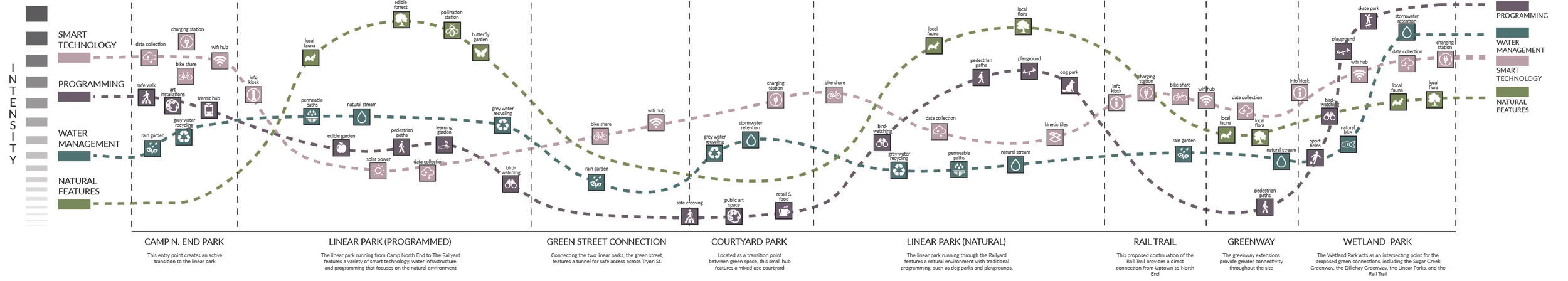
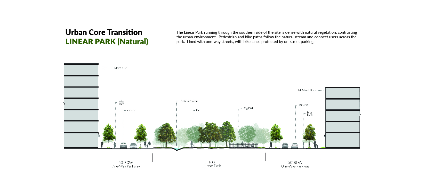
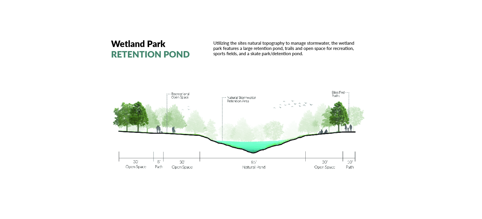
Total Site: 300 Acres | Linear Park (Programmed): 3.5 Acres | Linear Park (Natural): 5.5 Acres | Wetland Park: 24 Acres | Total Green Space: 40 Acres
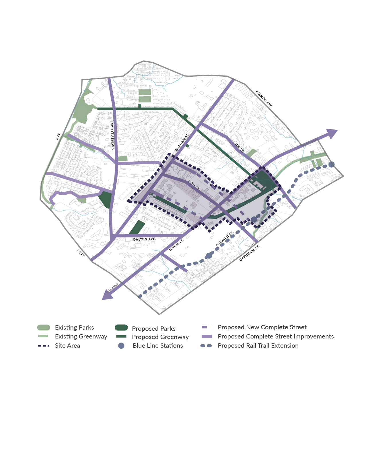
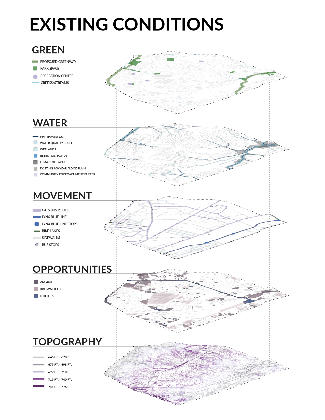
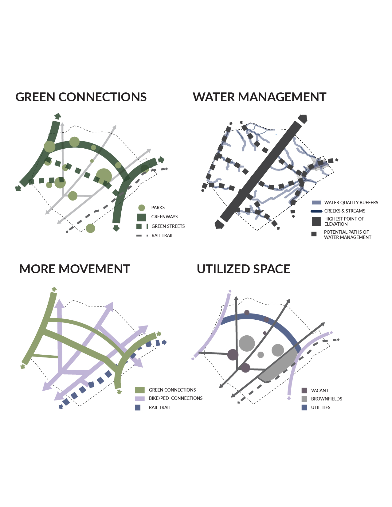
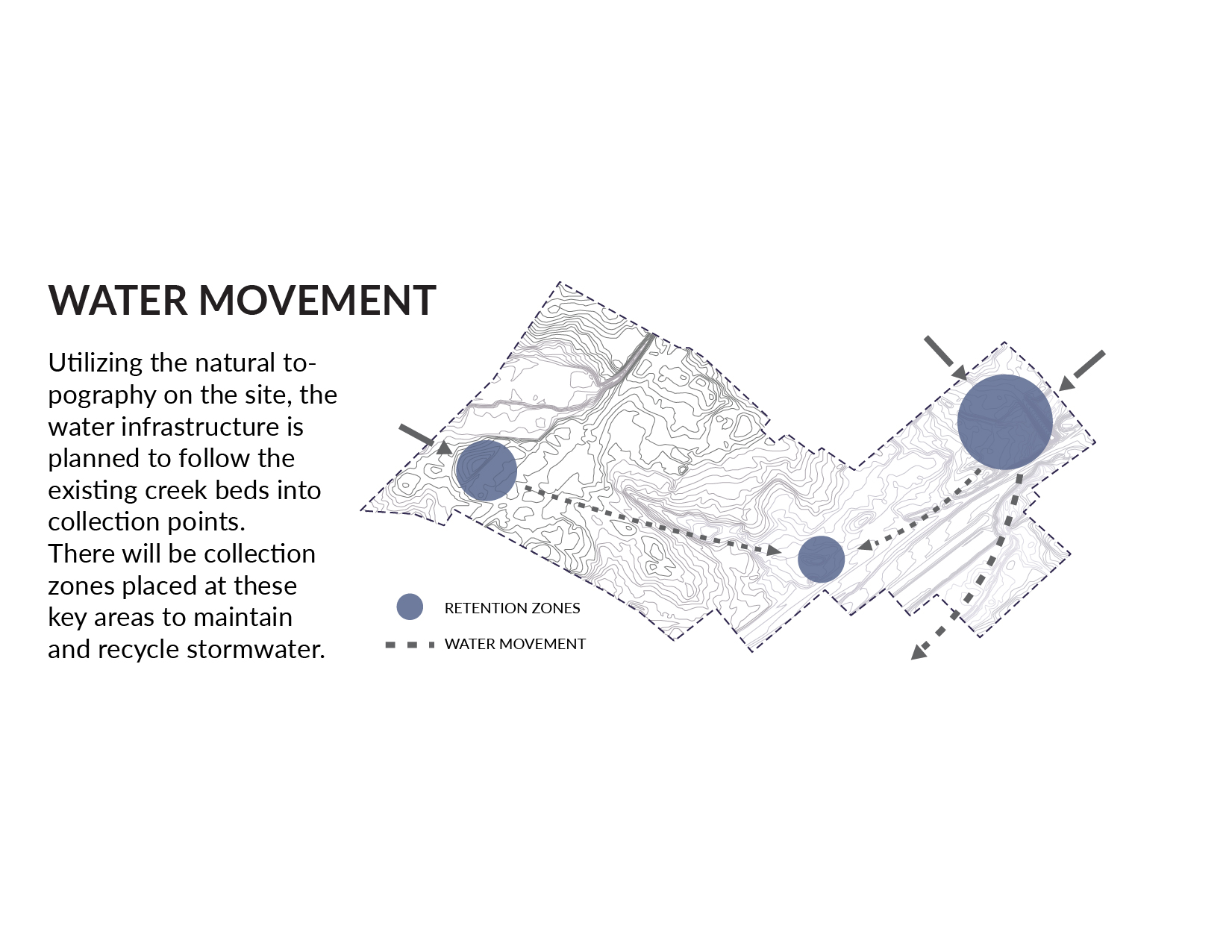
The North End Smart District currently has very minimal green space, with green-way extensions planned for the northwestern and southeastern boundaries of the site. Our design for a green network for the district includes green-way extensions, green streets, linear parks, and a series of other green spaces guaranteeing easy-access to open and natural space for every resident. The network makes use of vacant parcels and brown-fields, while utilizing the site’s natural topography to better manage storm-water.
THE VISION
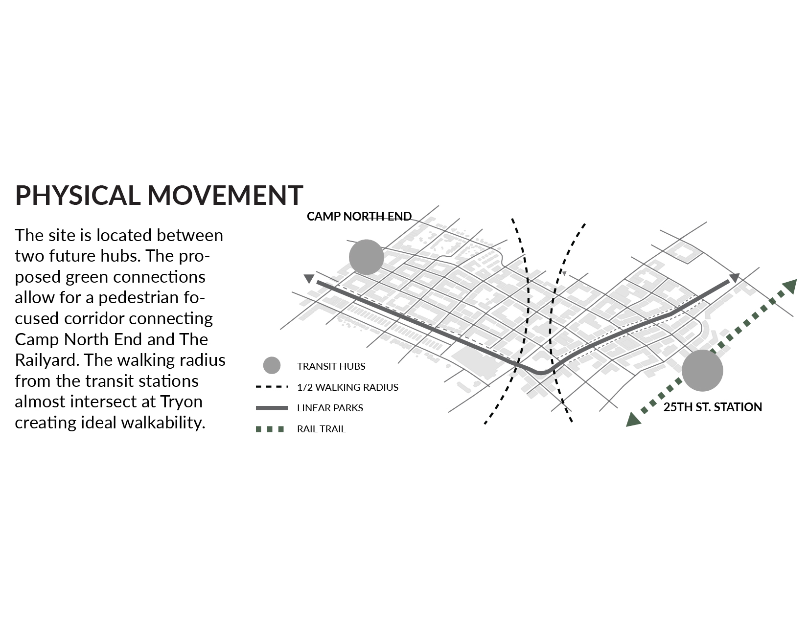
Creating a green connection from the future commuter rail station in Camp North End to the existing 25th St. light rail station, the site design utilizes its natural topography along with “smart city” elements to improve water management, while supporting an urbanized transit-oriented built environment. With over thirty-five acres of natural and open space, opportunities for recreation and physical activity are plentiful, benefiting both public and environmental health.
SPACIAL FEATURES
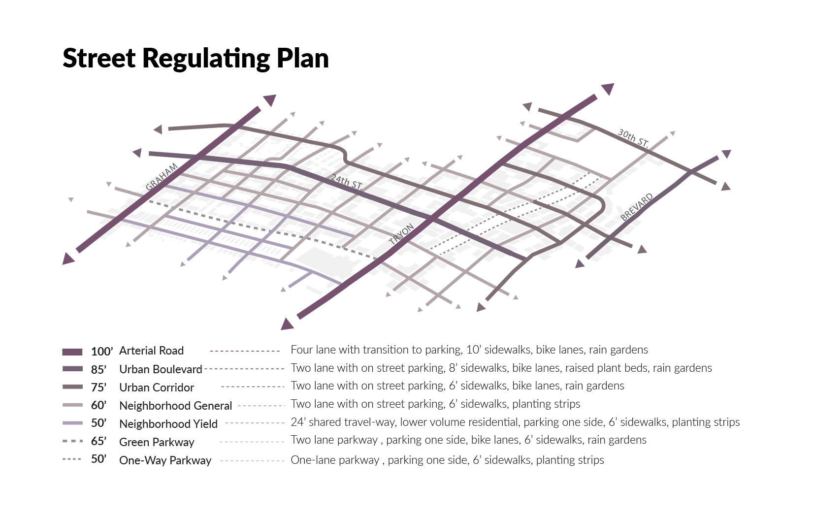
FORM BASED CODE
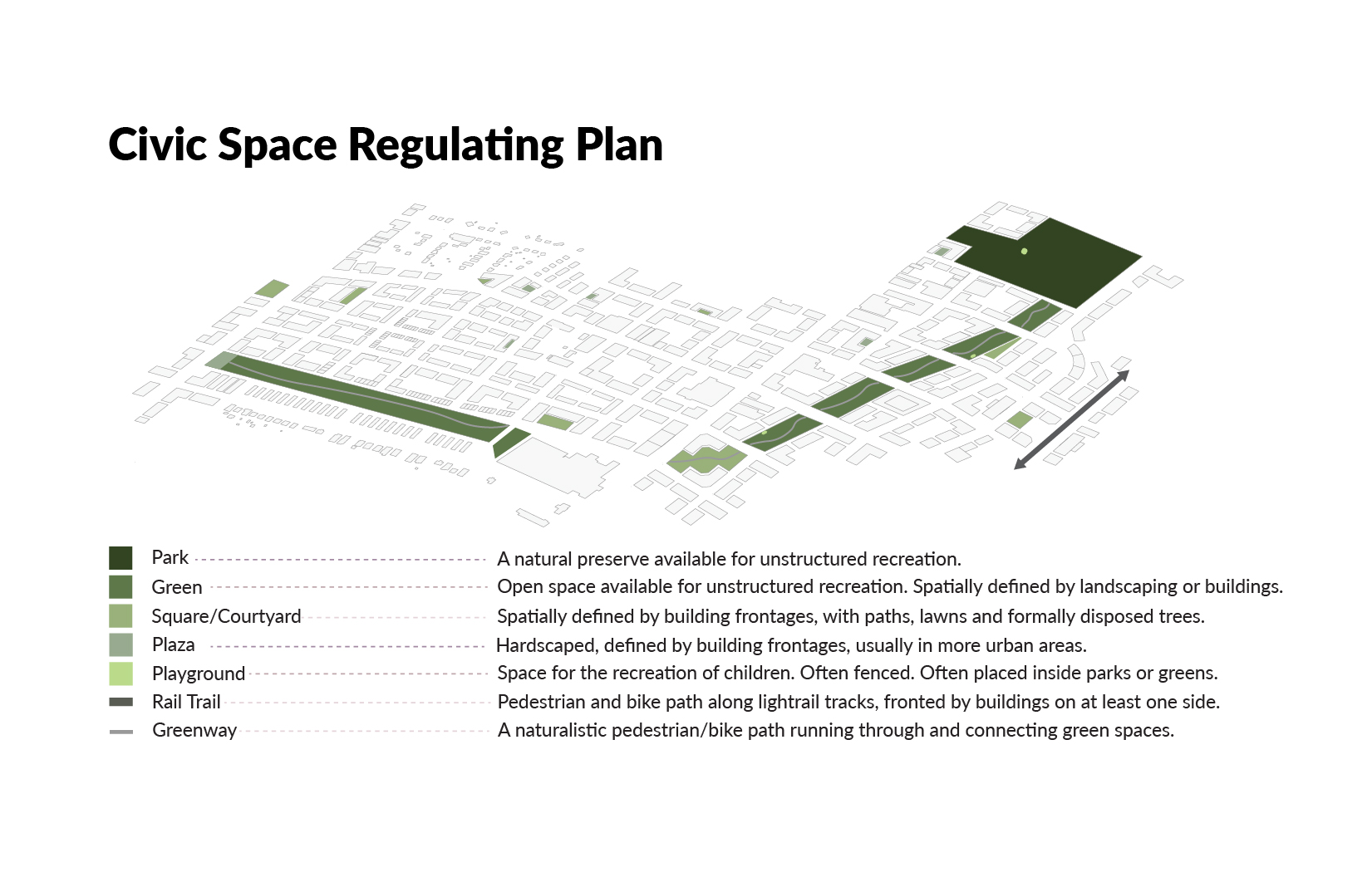
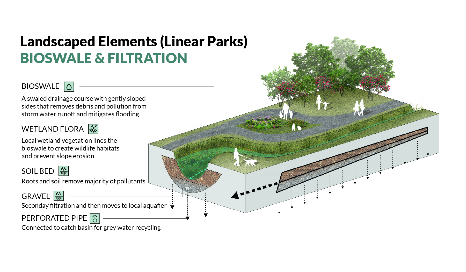
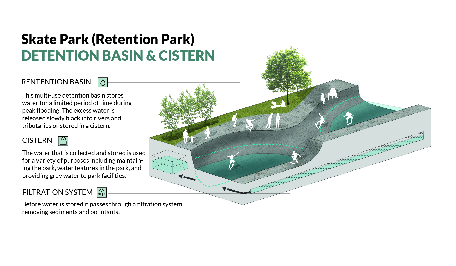
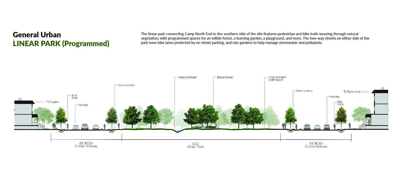
The linear parks feature pedestrian and bike paths that run along a natural stream, surrounded by a combination of open, natural, and programmed spaces. The twenty-four acre wetland park at the northeastern edge of the site creates a connection with the Sugar Creek Greenway and features large water retention zones, open recreation space, and sports facilities while preserving natural vegetation and wildlife habitats.

Wetland Park: Utilizing the site’s natural topography to manage storm water, the wetland park at the northeastern edge of the site features a large retention pond, with trails and open space for recreation. The natural vegetation allows for preserved and improved wildlife habitats.
The proposed Rail Trail extension through the site creates a vibrant outdoor space that promotes active transportation usage, while providing space for public art installations.
As part of the North End Smart District, the site utilizes many “smart city” strategies and technologies including grey-water recycling, stormwater retention, rain gardens, wifi and charging stations, data collection sensors, and bike share and repair stations.
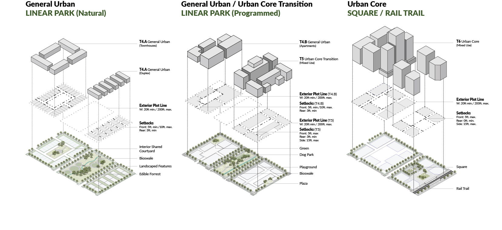
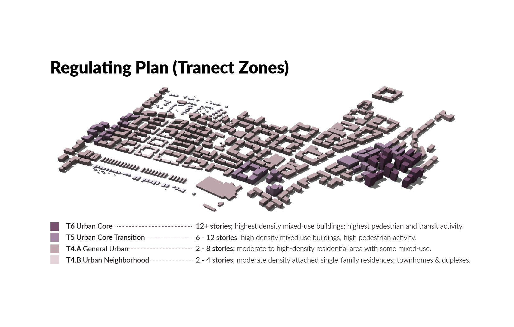
Using a form-based code to design the built environment, the site is made up of four different transect zones (T-Zones) ranging from a moderately dense residential zone (T4A) to a highly densified urban core centered around the light rail station (T6).

Camp North End: The Linear Park entrance, located on Graham Street adjacent to Camp North End, features a hard-scaped plaza surrounded by mixed use buildings. The central area of the plaza utilizes the site’s water recycling infrastructure and highlights a splash pad as its’ focal point.
SURGE TORONTO
Charlotte, NC (Winter 2018)
Molly Stahl (Team Leader), Kelsey Morrow, Tenecia Jones, Michael Paul James & Jeremiah Blanco
DESIGN
The City of Toronto is facing two powerful oncoming surges: 1) an estimated influx of 100k immigrants each year, and 2) increasing levels of stormwater, intensified by climate change. Each has the power to affect the physical, social, and economical composition of the city. Surge Toronto embraces these challenges with creative and adaptive design strategies, allowing Toronto to protect its established neighborhoods from the forces of nature while improving the health of its waterways, creating a vibrant mixed-use neighborhood, and providing opportunities for social and economic mobility.


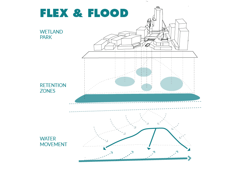
FLEX & FLOOD
This “floodable” district is capable of taking on the brunt of any storm, relieving surrounding neighborhoods of up to 16 million litres (4.2 million gal.) of stormwater and improving river health. A 1.8 ha. (4.6 acre) wetland park is capable of retaining up to 7.3 million litres (1.9 million gal.) of water, while its floating design elements allow it to be enjoyed recreationally in rain or shine. A network of rain gardens, cisterns, “water plazas”, and angled v-streets help retain and redistribute stormwater. By “going with the flow” and allowing controlled flooding, Surge Toronto complements the city’s ongoing river naturalization and flood protection projects while advancing globally in sustainable and resilient design.
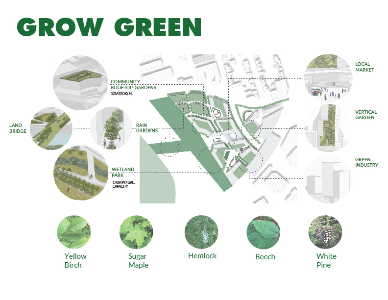
GROW GREEN
Environmental and public health are improved through the incorporation of sustainable and eco-conscious design strategies. An extensive network of green space covers 50% of the site, including over 1.2 ha. (3 acres) of rooftop gardens and an extensive network of rain gardens. The “floating” wetland park is landscaped with only native plant species, creating wildlife habitats and promoting river health. All new buildings on the site are LEED certified, increasing energy efficiency and decreasing long-term operational costs. Each of these strategies complements Toronto’s newly adopted Green Standard policy and contributes to achieving the city’s overarching sustainability goals, helping attract “green” industry to the area.
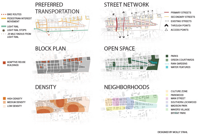
MAKE MOVES
Surge Toronto fosters physical, social, and economical movement. Located adjacent to the new transit hub, active transportation methods are prioritized in the site, with all roads designated as pedestrian-only, except the Broadview corridor. The highway ramp and parking for the site have been moved underground. Many of the buildings on site, including the transit hub, are accessible from underground, which is fitted to act as a flood-water retention zone when needed, capable of holding 8.5 million litres (2.2 million gal.). Elevated pathways provide pedestrian routes between the transit hub and many major destinations in the site, including the two hotels. A land bridge establishes a connection to the west side of the river, providing access to the amenities of the Corktown neighborhood, including recreational river access. The site promotes social and economic mobility by providing housing opportunities for residents of all stages of life and of all levels of income, with over 16% of units designated as affordable/work-force housing. The site also contains office space for businesses of all calibers, with many units designated for small business and incubator space.
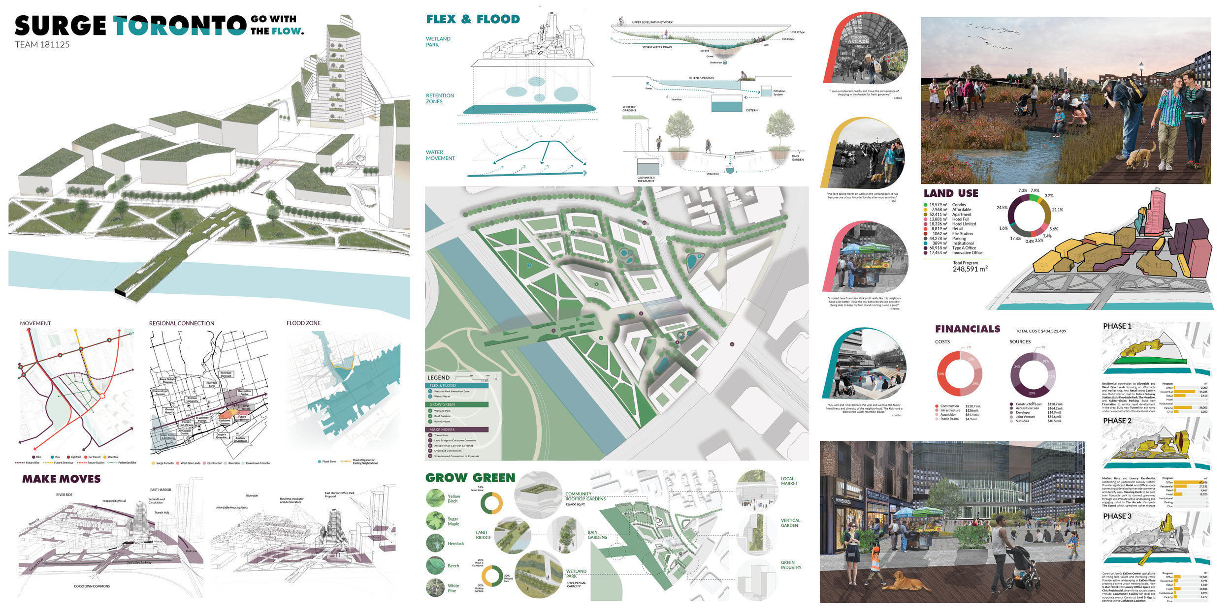


FINANCIAL
Studies have shown, that Toronto will be adding another 2 million people over the next 25 years. Toronto’s economy is booming, and companies from all over the world are looking to invest in the community and find a home for their businesses. Toronto’s start up and tech scene is growing and the demand for office space has never been in such high demand. A proposed mixed-use urban development will meet the demand of this growing economy. A combination of accessible subsidies, strategic financing and private equity partnerships support the feasibility of this development in three phases. Blocks A, B,C, and D were all acquired for this project. Zoning for this project has allowed for a dense multi-use development. This site will include two office towers, two hotels, and an abundance of retail and residential options. Approximately 16% of the dwelling units are reserved for households earning less than 80% of the Area’s Median Income
($78,280.00). Subsidies granted by the City of Toronto for their Affordable Housing Initia-tive have been accounted for throughout all phases of development.
PHASING
Surge Toronto is strategically divided into three phases:
Phase 1
focuses on introducing the community to our development. This phase includes the majority of our residential development to be completed. A small amount of office space will be completed, specifically we are introducing space focused around the co-working and start-up scenes. Extensive site analysis proved the lack of fire stations in this community. Surge Toronto will be add-ing a community fire station slightly over 1,000 sq. m. This station will not only serve this development, but also surrounding neighborhoods. Development costs for this phase are just slightly above $12 million.
Phase 2
introduces our largest mixed-use office tower, allowing room for several businesses to call it home. With this new influx of people during work hours we saw the need for introducing ground floor retail. Cost to develop just north of $40 million.
Phase 3
is the completion of our second hotel as well as a smaller mixed-use office tower. Community space will also be available for the public. A bridge that connects the site to the west will signify the completion of our development. Much of this phase is paid for by the public for the community use. This phase also includes the possibility of purchasing and renovating some older homes along Broadview in Riverside, creating a vibrant connection between our site and Queen St., an established cultural hub. Total cost for this phase is $79 million.
THE RAILYARD
Charlotte, NC (Fall 2017)
M. Stahl, W. Irving, T. Jones, C. Lamb, X. Li, J. Moore, K. Morrow, L. Pape, C. Polekar, D. Powell, R. Sonsakia, H. Valmeti, W. Tan
Exhibited at Charlotte Trolley Powerhouse Studio
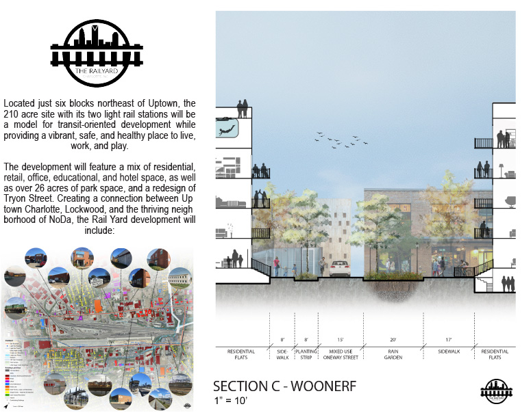
The Charlotte Railyard will be a new neighborhood that heals a gap in the urban fabric of the City of Charlotte.
Located just six blocks northeast of Uptown, the 210 acre site with its two light rail stations will be a model for transit-oriented development while providing a vibrant, safe, and healthy place to live, work, and play.
The development will feature a mix of residential, retail, office, educational, and hotel space, as well as over 26 acres of park space, and a redesign of Tryon Street. Creating a connection between Uptown Charlotte, Lockwood, and the thriving neighborhood of NoDa, the Rail Yard development will include:


● complete streets with wide sidewalks, protected bike lanes, pedestrian wayfinding signage, bicycle share and repair stations, and more that promote the use of active transportation methods and increase the health of residents and visitors of the area;
● vibrant and activity-filled spaces that promote com munity engagement so that Charlotteans of all ages and abilities can participate in public life;
● a mix of land uses within a close proximity so that Charlotteans can live, work, and play in a neighborhood without the need for an automobile;
● the preservation of a large portion of the natural vegetation of the site, the addition of thousands of new trees, the incorporation of rain gardens, and the decreased amount of automobile pollutants will all help improve the environmental health of the area.
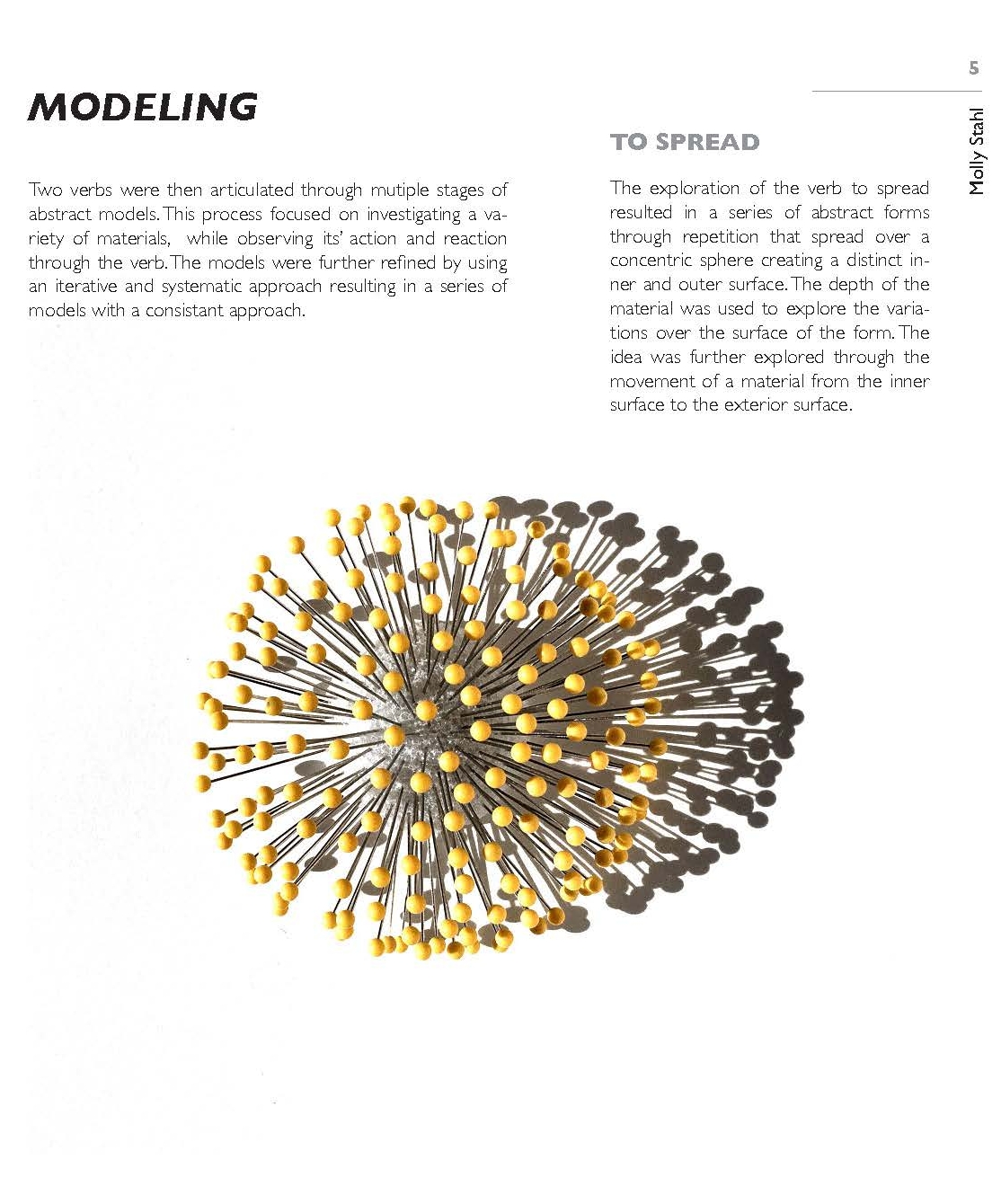
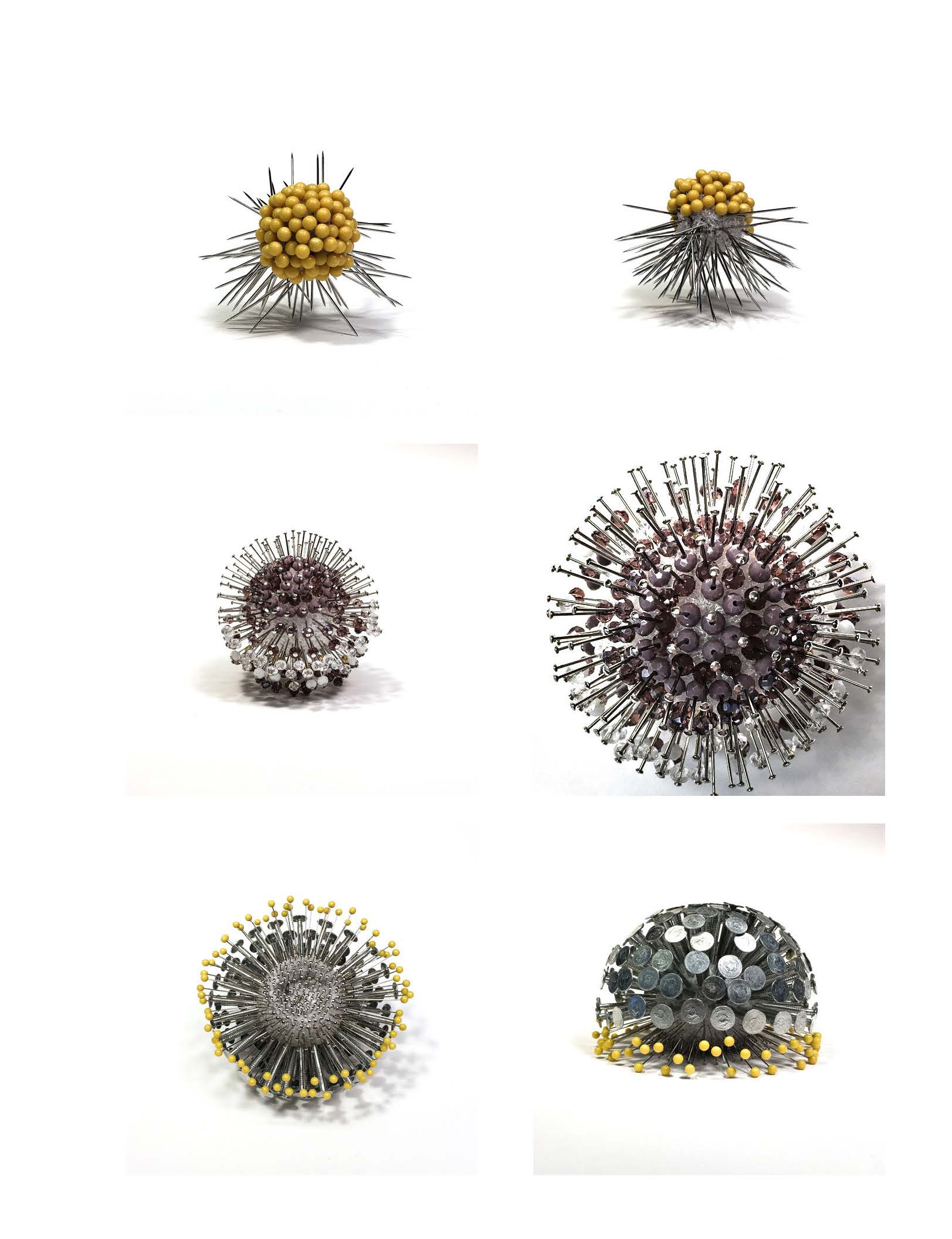
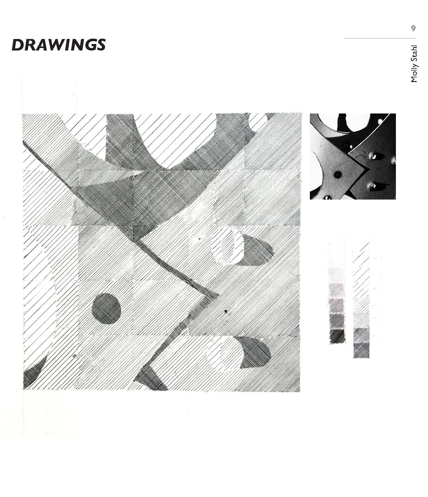
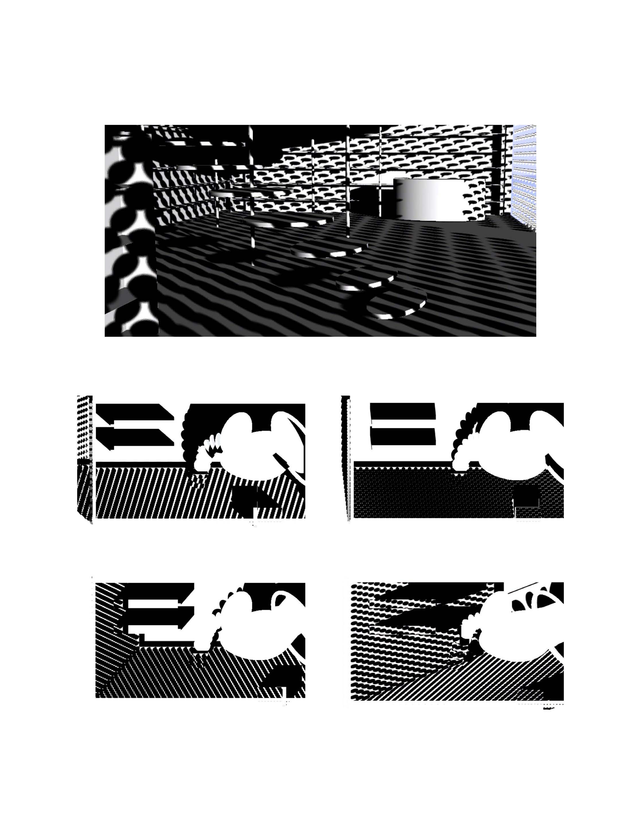
A STUDY OF VERBS
Book Shop Facade (Summer 2017)
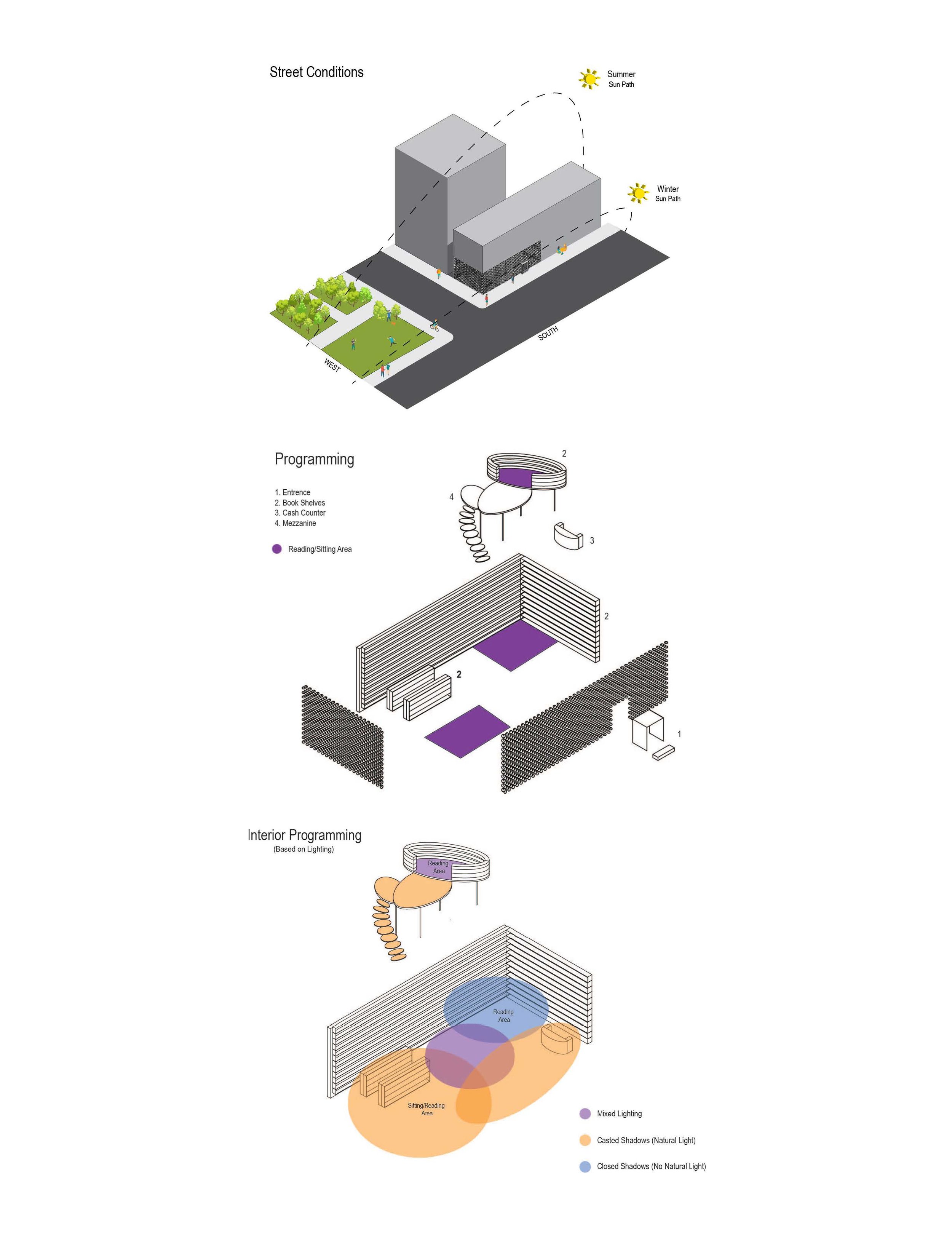
The approach to the book shop design concept was a culmination between the two initial action verbs, to spread and to light. Taking the basic principles of both and combing them it created a systematic approach to the facade. Using a repetitive design spread across the exterior it allowed light to penetrate the surface in to create shadow densities and dispersals on the interior to denote programming space.


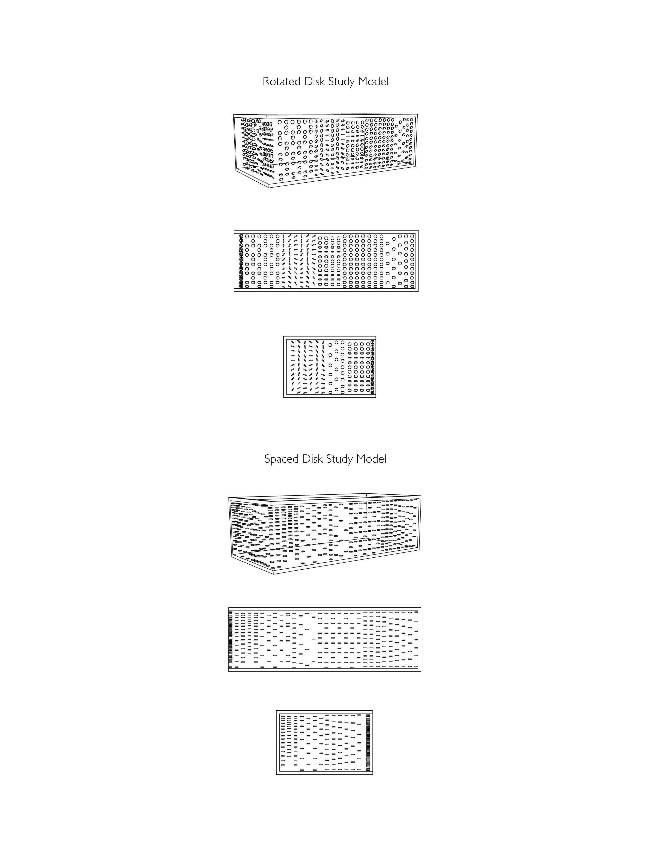
The initial studies of the bookshop facade experimented with rotation, spacing and density. This progressed to a refined model that used a single line of disks rotated gradually from a 45 degree angle to a 90 degree angle across the exterior. The densest areas of cover being at the intersecting South and West facade.
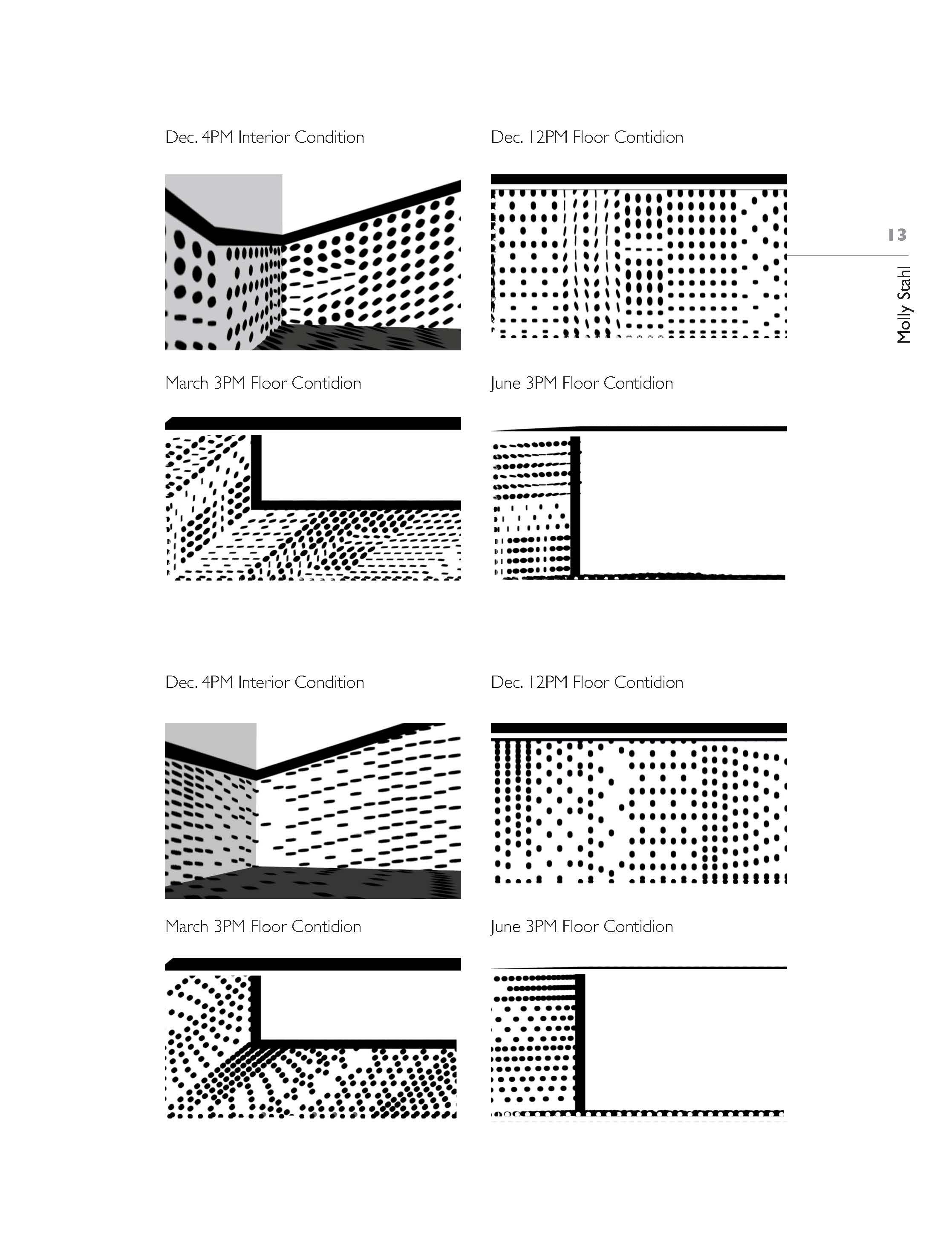
Shadow movement on the interior space, based on the progression of time throughout the day and year, denoted the programming space of the bookshop as well as the interior structures including the mezzanine, bookshelves, cash counter, vestibule, and staircase. Each of these elements also contributing intention shadows further denoting programming space.

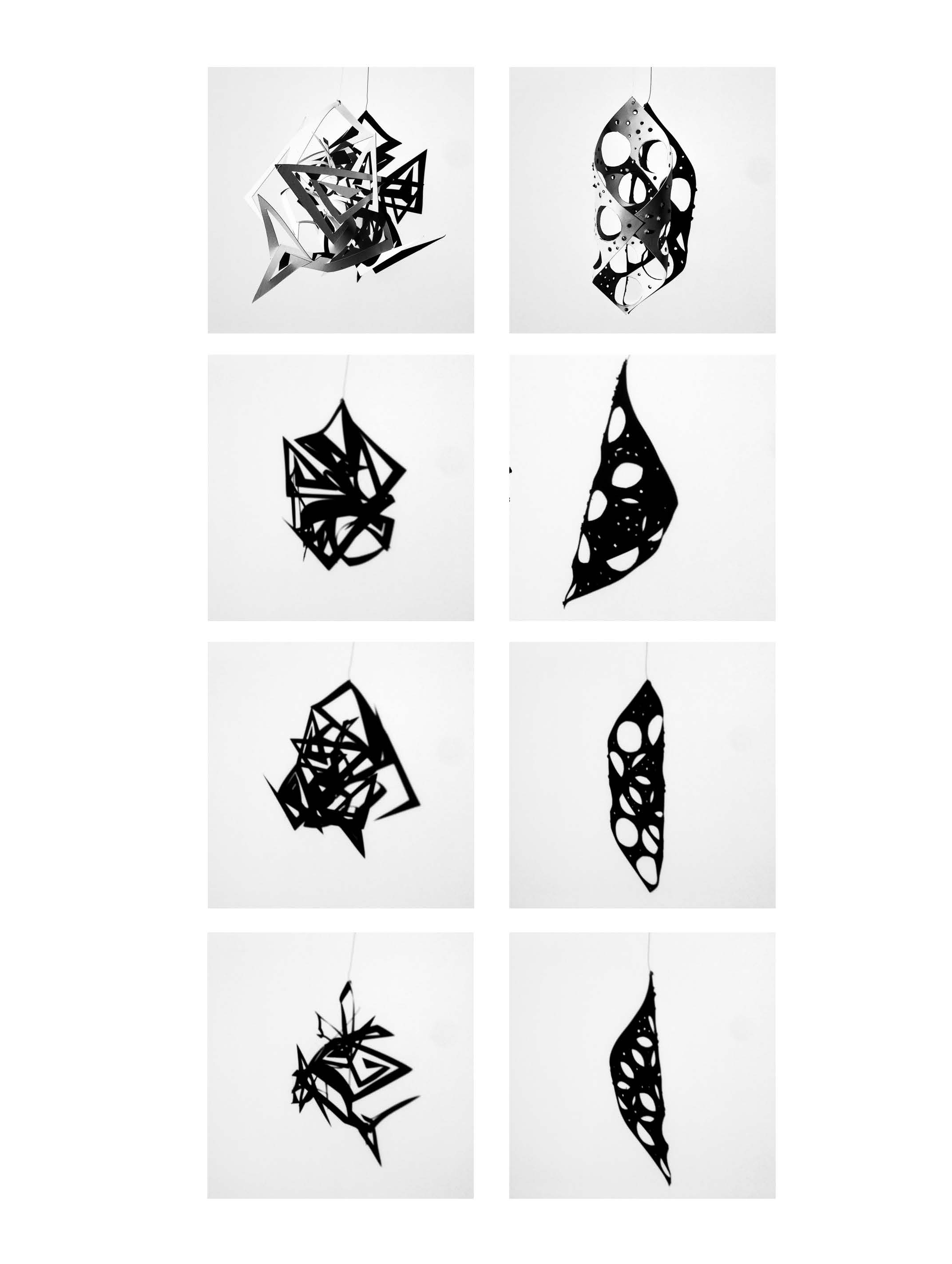
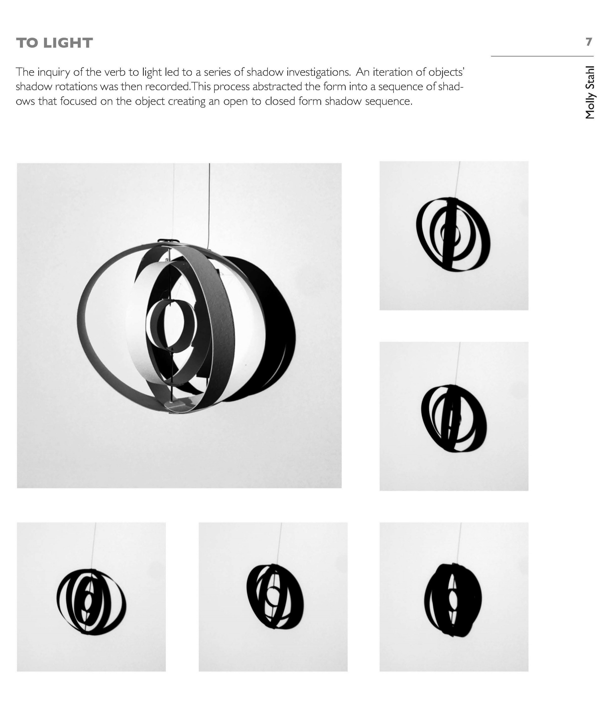
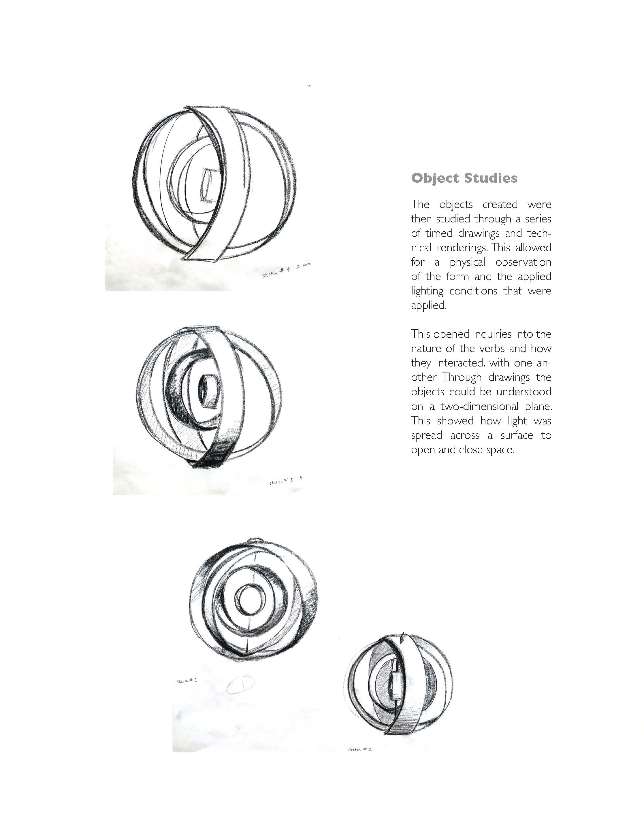

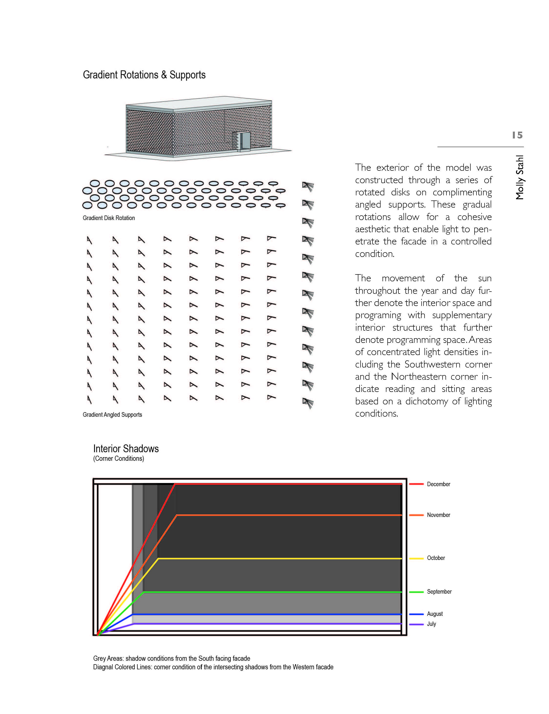
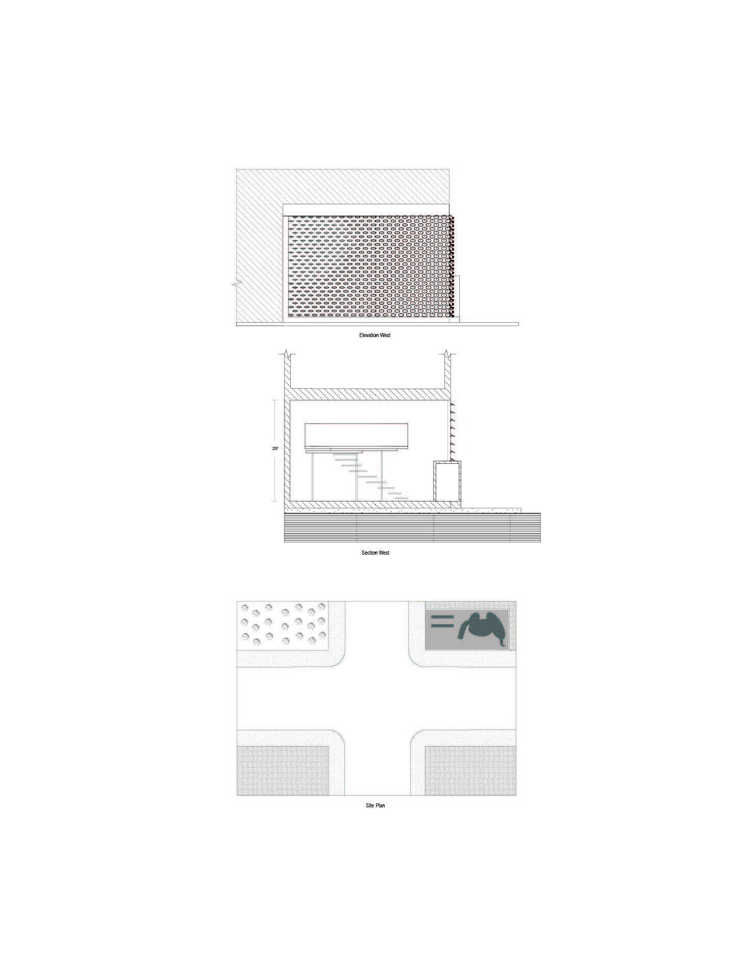
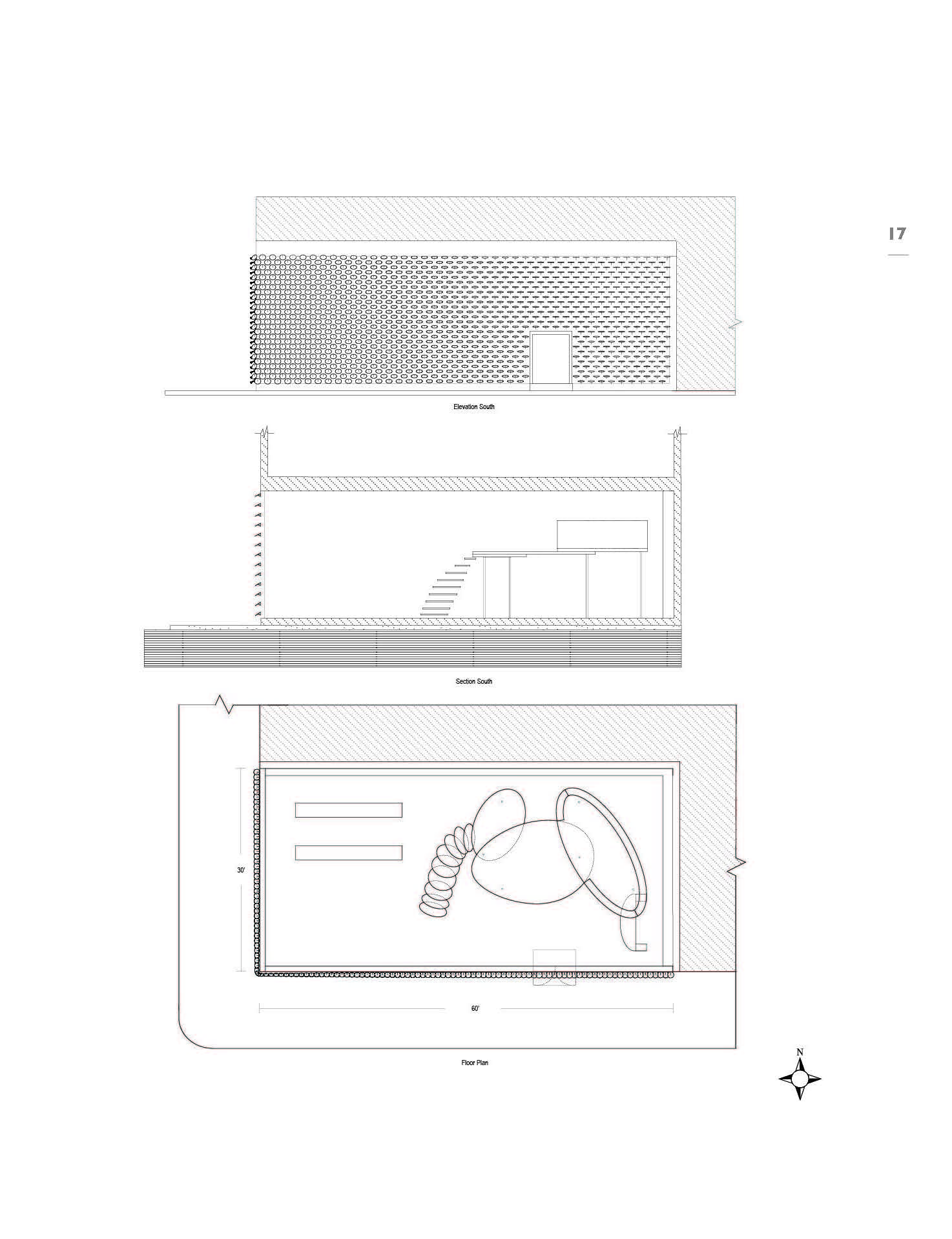
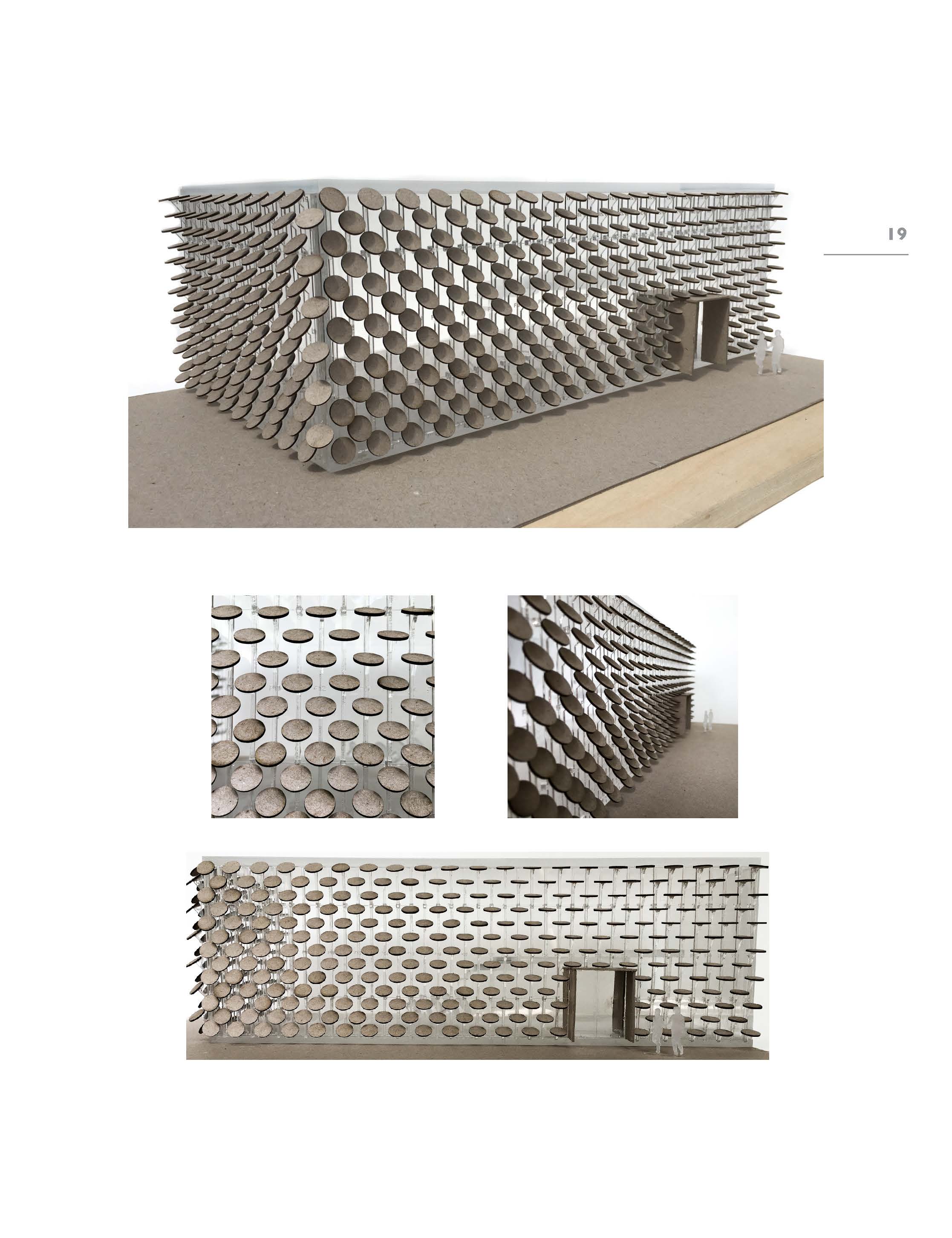
The exterior of the model was constructed through a series of rotated disks on complimenting angled supports. These gradual rotations allow for a cohesive aesthetic that enable light to penetrate the facade in a controlled condition.
The movement of the sun throughout the year and day further denote the interior space and programing with supplementary interior structures that further denote programming space. Areas of concentrated light densities including the Southwestern corner and the Northeastern corner indicate reading and sitting areas based on a dichotomy of lighting conditions.


PUBLIC SPACE ANALYSIS
Prague, Czech Republic (Summer 2018)

SMART DISTRICT ANALYSIS
Charlotte, NC (Spring 2018)


HIDDEN VALLEY ANALYSIS
Charlotte, NC (Spring 2018)


UNIVERSITY CITY ANALYSIS
Charlotte, NC (Fall 2017)


DINOSAUR ALPHABET
Charlotte, NC (2016)
Filling the need of my love of painting, this series of dinosaur illustrations was created as personal project when I had way too much time on my hands and far too many episodes of the X-Files to watch. While some children love toy trucks my nephew loves dinosaurs. At two he could tell you the scientific name of just about any dinosaur you showed him.
From A to Z this project consists of a variety of hand painted watercolor illustrations representing dinosaurs from all periods and walks of extinction. Designed because of and for my nephew who is constantly inspiring me.


